


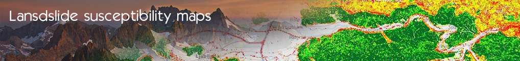

Susceptibility Map Of Triggering Landslides Due to Rainfall Forecast (GEO-ZS)
The system will predict (in a best possible way) the areas where the probability of triggering landslides will be increased due to higher precipitation levels. The endangered zones will be predicted using the combination of:
• the landslide susceptibility model,
• the precipitation forecast and
• the landslide triggering threshold values.
The main goal is to make fully automated system (automatically pushing data in to the cloud, GIS modelling for predicting landslide events and creating WMS or WFS map services). This service will provide information about geo-hazards induced by mass movement process. The dissemination enables effective access to the location of landslides and landslide susceptibility map. The service will be available in WMS and WFS.
• Grid 12,5x12,5
• Scale 1.250.000
The use case is split in 2 business processes:
• the process for the provider in charge of the push of raw data and the execution of the calculation of Landslide prediction,
• the process of the user who search and re-use data created by the system.
- Log in to post comments
Last updates
Project's Calendar

Only for consortium members
Contact: you can contact the Consortium using the generic address: contact [@] ingeoclouds.eu. Thanks!
This project is partially funded by the European Commission CIP Program. This website reflects the views of the authors only, and the Commission cannot be held responsible for any use which may be made of the information contained therein.

InGeoCloudS Users Documentation and other documents of this Web
site by the InGeoCloudS consortium members
are licensed under a Creative Commons Attribution-NonCommercial-ShareAlike 3.0 Unported License.
Based on a work at http://www.ingeoclouds.eu/.
Ad banners and pictures are (c) AKKA Technologies