


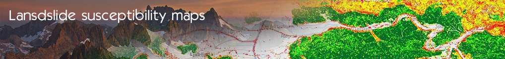

Active Landslide Inventory Mapping and Susceptibility Zoning (EKBAA)
The use case will provide an active inventory map of the occurred landslides (e.g. location, classification, volume, activity, date of occurrence of landsliding etc) updated after every new event recorded in the database. It will be possible to retrieve data concerning the landslides’ characteristics (type of movement, causes, season and year of occurrence etc), as well as any information available for the region of occurrence (geology, precipitation, altitude, slope etc). Taking into account the above data, a division of the land into homogeneous areas will be produced according to the landslides’ occurrence percentage (Landslides’ density map). Additionally, it will be possible for the users to select one or more specific parameters or characteristics and calculate the frequency of landslides accomplishing these criteria.
The calculation of the spatial probability will produce a susceptibility zoning map available to the system. The map will be a result of the analysis between the spatial distribution of the landslides (landslides’ density) and a group of generative causes (geological, topographical, hydrological etc characteristics of the area) based on the fact that landslides in the future will occur under the same circumstances that they occurred in the past.
Maps used for the above analysis will be also available (e.g. digital terrain model, land use map etc).
Potential users shall be national government officials, local and other public sectors authorities, universities, scientific associations, geological surveys, individuals, stakeholders etc.

- Log in to post comments
Last updates
Project's Calendar

Only for consortium members
Contact: you can contact the Consortium using the generic address: contact [@] ingeoclouds.eu. Thanks!
This project is partially funded by the European Commission CIP Program. This website reflects the views of the authors only, and the Commission cannot be held responsible for any use which may be made of the information contained therein.

InGeoCloudS Users Documentation and other documents of this Web
site by the InGeoCloudS consortium members
are licensed under a Creative Commons Attribution-NonCommercial-ShareAlike 3.0 Unported License.
Based on a work at http://www.ingeoclouds.eu/.
Ad banners and pictures are (c) AKKA Technologies